- Air Homepage
- Air Quality Testing
- Aermod
AERMOD - A user-friendly model for air quality
AERMOD is my favorite air quality model for Alberta. Why? It's a cost-effective, well-understood, up-to-date, scientifically defensible, and widely accepted model. For my job as an environmental consultant, I use this model to assess near-range air pollution impacts 20 km or less from air emissions sources.
Here's the science behind Alberta's choice air model, AERMOD - What makes this air quality model the scientifically defensible, cost-effective tool (covering the ground within 20 kilometers of your facility) for almost every industrial permit? Unlock AERMOD's success secrets, from its use of advanced WRF weather data to its Building Downwash Enhancements.
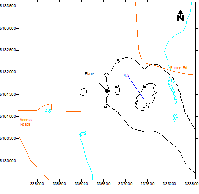
As seen in the drawing above, black curves are isopleths of equal concentration (like elevation contours on a topographical map, joining points with equal elevations.)
Why AERMOD?
For assessing pollutant dispersion and impacts, AERMOD (American Meteorological Society/Environmental Protection Agency Regulatory Model) is widely used. There are several reasons why AERMOD is preferred by many air quality professionals, even if it's not universally "better" than other models:
- Many environmental agencies and organizations worldwide accept AERMOD as a standard regulatory model. Environmental impact studies, compliance assessments, and permitting often require or recommend its use.
- The AERMOD model is based on sound scientific principles and incorporates state-of-the-art techniques for modeling atmospheric dispersion. To estimate pollutant concentrations accurately, it uses advanced meteorological data processing, turbulence modeling, and pollutant transport algorithms.
- With AERMOD, you can customize the model to fit specific scenarios and sites. Detailed and site-specific modeling is possible with different source types, terrain conditions, building effects, and receptor locations.
- AERMOD has been tested, validated, and compared to field measurements and other air quality models. With its good performance in a wide range of weather and terrain conditions, it's reliable in many situations.
- Users will love AERMOD's user-friendly graphical interfaces and user support tools that make model setup, data input, and result analysis a breeze. Modelers of all levels can use it because of its comprehensive pre- and post-processing capabilities.
- AERMOD is constantly refined and updated based on scientific advances and feedback from the air quality modeling community. As a result, the model stays up-to-date with evolving regulatory requirements.
There's no perfect model for everything. Air quality models are suitable based on specific modeling objectives, site characteristics, available data, and regulatory requirements. Different models have strengths in different areas or specialized applications. Choosing the right model requires consulting with air quality experts and taking your project's needs into account.
In most Alberta industrial facilities, this is where all the action happens. How so? With the exception of major cities and big complexes like the oil sands, Alberta's sites are mostly quite isolated, with the most important sources confined to a small area.
The model is relatively easy to use; you can run it on a desktop or laptop PC and it usually takes less than a few hours. For straightforward communication of predicted air quality impacts, the model methodology and results can be shown to our regulatory agencies like Alberta Environment and Protected Areas, the Alberta Utilities Commission, or the Alberta Energy Regulator.
AERMOD Meteorology and Input Data
With the exception of the mountainous regions, this describes most of Alberta. As outlined in the Alberta Air Quality Model Guideline, basic meteorological and topographical data are readily available for most places worldwide. Penn State/NCAR Mesoscale Model (MM5) data were used in our assessments until 2021. Since then the preferred meteorological data has been provided by the Weather Research and Forecasting (WRF) model, a widely used modern numerical weather prediction system. By solving complex mathematical equations representing the physics and dynamics of the atmosphere, it simulates and forecasts weather patterns.
To produce detailed and accurate forecasts, WRF incorporates various atmospheric variables, like temperature, humidity, wind speed, and atmospheric pressure. Data from weather observations, satellites, radar, and other sources is used to initialize the model.
Meteorologists can analyze weather phenomena at a local or regional scale thanks to the WRF model's ability to provide high-resolution forecasts. Fine-scale atmospheric processes play a big role in predicting weather in complex terrain, like mountains or coastal regions.
Weather research, operational forecasting by meteorological agencies, and specialized applications like air quality modeling and hurricane prediction use the WRF model. Researchers can customize and modify various model components to suit specific research or forecasting needs.
To enhance the accuracy and usability of the WRF model outputs, users can access a range of tools, data assimilation techniques, and post-processing capabilities. Due to its open-source nature, the model encourages collaboration and innovation within the meteorological community, enabling continuous improvements.
It's assumed the weather stays the same from plume release to ground impact. It's called steady-state over short distances. When AERMOD works best:
- If any chemical transformations are needed after release, they're handled easily,
- As you get farther from the source, the terrain rises and falls gently,
- At any time, the weather is the same across all models
- It's rare to have calm wind speeds.
Additionally, this model tends to overpredict concentrations resulting from relatively short stacks, so it's safe to use for regulatory assessments.
For internal calculations, AERMOD integrates the six distinct stability classes into a continuum, incorporating a planetary boundary-layer similarity theory. During periods with strong vertical mixing, non-Gaussian dispersion coefficients take over and produce more accurate concentration predictions near the stacks than otherwise.
In terms of more complex facilities, what should be considered?
Using Plume Rise Model Enhancements (PRIME) and Building Profile Input Program (BPIP) increases close range accuracy, making it perfect for plant sites with buildings between stacks.
Earlier this century, this model has replaced the long-standing model of choice, Industrial Source Complex (ISCST3), at the US Environmental Protection Agency (EPA). Using my assessment, I can calculate many sources, buildings, and receptors simultaneously, so I can provide a thorough study.
AERMOD modelling assessments are probably the most effective and efficient way to model regulatory air dispersion. Please email Barry J. Lough at Calvin Consulting Group Ltd. at this address for help with any questions you might have.
Thank you.

The AERMOD model is an efficient tool for predicting air quality in Alberta.
Which air quality model is most suitable for the majority of Alberta Air Quality Model Guideline regulatory modeling? AERMOD
It is easy to use, versatile, and widely recognized. Come and see for yourself.
Do you have concerns about air pollution in your area??
Perhaps modelling air pollution will provide the answers to your question.
That is what I do on a full-time basis. Find out if it is necessary for your project.
Have your Say...
on the StuffintheAir facebook page
Other topics listed in these guides:
The Stuff-in-the-Air Site Map
And,
Thank you to my research and writing assistants, ChatGPT and WordTune, as well as Wombo and others for the images.
OpenAI's large-scale language generation model (and others provided by Google and Meta), helped generate this text. As soon as draft language is generated, the author reviews, edits, and revises it to their own liking and is responsible for the content.


New! Comments
Do you like what you see here? Please let us know in the box below.