- Air Homepage
- Canadian Weather
- Canadas Climate
Map of Canadas climate...
There's no one
Canadas climate as we have a few...
With this much territory, you would too...
This page gives a map and descriptions for you...
Enough with the poetry, on with the show.
Find more Canadian weather information.
Canada's weather extremes: A Continent of Climates - Imagine a country so huge it has everything from mild rainforest to permanent ice caps, where the average low in January swings by more than thirty degrees! See here, the stunning variety in climates that shapes Canada's different regions, from the sunny Prairies to the humid East, with detailed maps of temperature, snow, and sunshine.
Canadian climate has a lot to offer. From the cold Arctic tundra to the mild temperate rainforest, Canada has one of the world's most diverse climates. Warm summers and cold winters make it an ideal place to study climate change and global warming because Canadian weather patterns might affect the rest of the world.
According to the Intergovernmental Panel on Climate Change (IPCC):
"Climate in a narrow sense is usually defined as the average weather, or more rigorously, as the statistical description in terms of the mean and variability of relevant quantities over a period of time ranging from months to thousands or millions of years. The classical period is 30 years, as defined by the World Meteorological Organization (WMO). These quantities are most often surface variables such as temperature, precipitation, and wind. Climate in a wider sense is the state, including a statistical description, of the climate system."
The current situation with Canada's Climate
What does it mean? Anybody's climate, including Canada's, describes the weather for a part of the world, at a given time of year, without the benefit of a forecast.
If you come to Canada sometime next year, for example, here's what you should expect. A detailed description would tell you what temperatures to expect, if there will be rain, strong winds, or snow.
First of all, Canada is one of the biggest countries in the world. It spans more than four time zones and has land ranging from temperate mid-latitudes in its southern border all the way northward to 80°N.
That means Canada's climate is a unique and varied blend. Several areas, each with its own big influence, like:
- latitude
- nearby oceans and lakes
- mountains, and even
- Vegetation (surface cover)
- cities.
Canada's current weather is governed by a so-called air mass affecting a particular region at any given time. Several of these influence Canada's climate at once. The terms maritime-tropical, continental-polar, arctic, etc., define the temperature (generalized by the second word in each two-word phrase) and humidity characteristics of a large blob of air.
Even though they move around, many display quasi-permanent qualities (moving, but not too far) for a significant part of each year. It certainly affects regional climates and helps define Canada's climate.
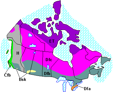
We know Canada has different climates. The Köppen Climate Classification is an elementary system that draws climatic conclusions based on temperature and precipitation variations along with vegetation type and amount. The southwest city of Vancouver, surrounding coastal regions, and islands get a Köppen code of Cfb. Most of the time, the capital C means cool, humid air, like in England.
The 'f' means no distinct dry season and the small 'b' means comfortable temperatures in the summer (around 20°C) with a growing season of at least 3 months.
Here's where Canada's climate is mildest. East of Vancouver, southern British Columbia has high mountains with a polar climate called Highland H, interspersed with deep, often dry valleys. The cities of Kelowna and Kamloops, and other places in the deep valleys, might have Koppen BSk climates, which means there's less precipitation, big day/night and summer/winter temperature differences. Most of the southern and central interior is Dfb, where the D means continental conditions: also big temperature differences but not quite as dry.
Out of the mountains, as you head east, you'll find a large sweeping area of Dfb climates in the south, with great summers for agriculture, some rain but not too much, and cold, dry winters. Palliser's Triangle, especially, is often influenced by the hot US deserts south of here. It stretches from Calgary climate area into southern Saskatchewan, where more of the hottest and driest climatic extremes of Canada are found (semi-arid grassland steppe: Medicine Hat, Regina).
There's a cooler, slightly moister band of Dfb north and east of here, including the humid continental cities of Edmonton and Winnipeg. In the north you'll find the less-populated Boreal Forest with its Dfc climate - short summers and harsh winters.
Let's talk about the largest part of Canada's climate. In general, northern British Columbia, Alberta, Saskatchewan, Manitoba, Ontario, and Quebec (The Canadian Shield), as well as Labrador, the southern Yukon, Northwest Territories, and Nunavut have the code Dfc (I think it means "Darn friggin' cold!").
There are arctic climates further north classified as ET, tundra, which has no forest and little vegetation of any type. Some Canadian land has permanent ice caps, coded EF (in isolated areas that are too small to show here), rather than large sheets like those in Greenland, the Arctic Ocean and Antarctica.
Let's head south to the southeastern part of the country. Toronto's golden horseshoe gets its name from the most densely populated tract surrounding the west end of Lake Ontario, with some of the warmest climates in Canada. The climate is Dfa in some spots, especially down south near Lake Erie and further west to Windsor, which is adjacent to Detroit. Summers are very warm and winters are shorter than most of Canada.
The rest of southern Ontario, including Ottawa, is Dfb, and the north is Dfc. Along the St. Lawrence River and through Halifax and all the maritime provinces, the Dfb extends eastward into Montreal. It's more humid here, with warm summers and cold winters.
Fill in the name of your city in the blank on this page on weatherspark.com to get detailed climate information for Canada. Then you get expected normal weather for every month and a sense of variability.
Canadas Climate Details
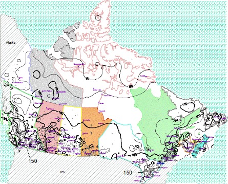
Here are some contour plots showing Canada's climate:
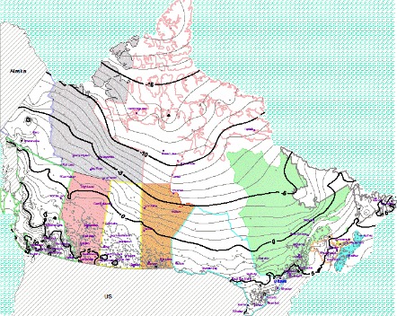
Average Annual Temperature
For every locale in the country, this plot shows the average temperature in degrees Celsius (°C) 24/7 over 365 days. The data in these plots was extracted and compiled by Environment Canada and covers 1981 to 2010. Here's a bigger version with greater resolution: https://stuffintheair.deviantart.com/art/Canada-Annual-Average-Temperature-52717107
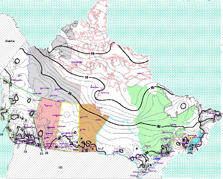
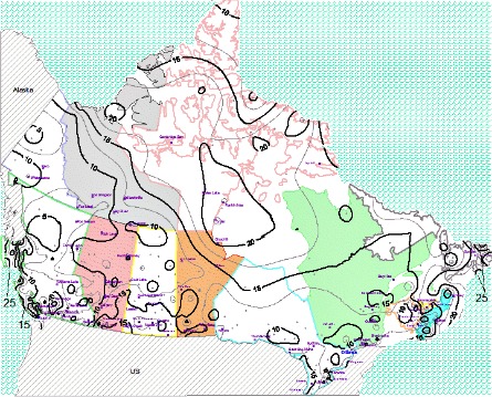
Average July High Temperature
Here's the average daily high temperature for July, the warmest month. Every summer, each place can expect to surpass the corresponding temperature 50 days or more. Larger version: https://stuffintheair.deviantart.com/art/Canada-July-Average-High-Temperature-527172257
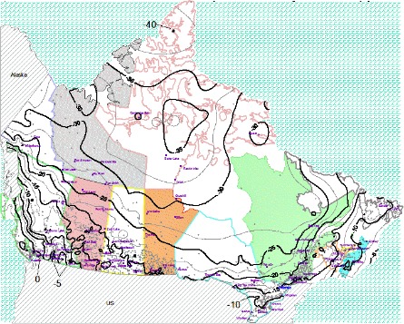
Average January Low Temperature
For the whole country, this plot shows the average daily low temperature in January, the coldest month. The most notorious aspect of Canadas climate. Around 50 nights out of the year, each place gets colder than the corresponding temperature. Larger version: https://stuffintheair.deviantart.com/art/Canada-January-Average-Low-Temperature-527171848
Average Windspeed
Here's the average wind speed everywhere, in kilometres per hour. See a larger version at: https://stuffintheair.deviantart.com/art/Canada-Annual-Average-Windspeed-527174263
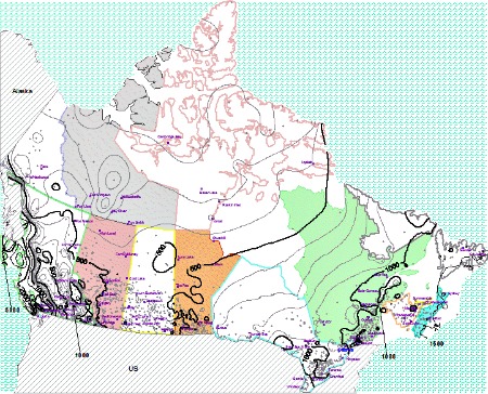
Average Annual Precipitation Total
For each region, this plot shows the total precipitation in millimetres from all rainfall and melted snowfall. Take note of how dry the prairies are (less than 500) and how much rain falls on the coastal areas (well over 1000).
Larger version: https://stuffintheair.deviantart.com/art/Canada-Annual-Precipitation-527173492
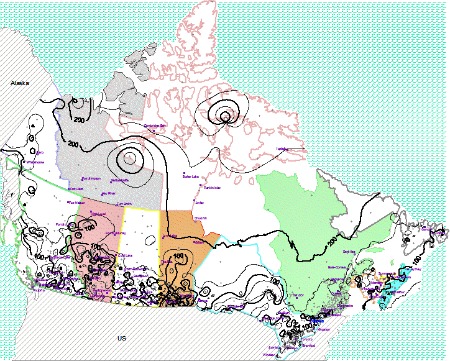
Average Number of Days with Snow on the Ground
How long are our winters? It varies by location. You can use this figure to compare winter durations (in days) if you consider winter to be a time with at least 1 cm of snow on the ground. There are many local variations, but the trend is visible. Larger version: https://stuffintheair.deviantart.com/art/Canada-Annual-Number-of-Days-with-Snow-On-Ground-527173941
Average Sunshine as a Percent of Daylight Hours
You'll love the southern prairies if you like sunshine. You can see here how many daylight hours the sun shines brightly. Larger version: https://stuffintheair.deviantart.com/art/Canada-Annual-Sunshine-Percent-527173028
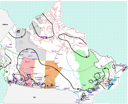
Average Frost-Free Growing Season
Here's the average gardening and growing season for each area. Each year, it shows the mean number of consecutive frost-free days. Larger version: https://stuffintheair.deviantart.com/art/Canada-Annual-Frost-Free-Days-527172693
An old Canadian classic I sang a cover of - Seasons in the Sun.
I have a lot of other great songs on my Youtube channel. Enjoy!
Have I got the Wrong Idea?
Maybe you know something I don't. Something the world needs to hear about. This short website cannot include everything and if it's important to you, it's important to me.
So what's really the story with global warming? I'd like to know. If you have a picture, I'll even include it here. Try me.
Navigate back from Canadas Climate to the Weather Canada web page.
Search this site for more information now.
Have you ever visited Canada and experienced our climate?
An overview of the climate and air masses of Canada. Also a list of the major cities.
Do you have concerns about air pollution in your area??
Perhaps modelling air pollution will provide the answers to your question.
That is what I do on a full-time basis. Find out if it is necessary for your project.
Have your Say...
on the StuffintheAir facebook page
Other topics listed in these guides:
The Stuff-in-the-Air Site Map
And,
Thank you to my research and writing assistants, ChatGPT and WordTune, as well as Wombo and others for the images.
OpenAI's large-scale language generation model (and others provided by Google and Meta), helped generate this text. As soon as draft language is generated, the author reviews, edits, and revises it to their own liking and is responsible for the content.



New! Comments
Do you like what you see here? Please let us know in the box below.