- Air Homepage
- Upper Atmosphere
- Conservation Momentum
The Law of Conservation Momentum and Weather in a Moving Atmosphere
Conservation momentum alters our weather systems in special ways in meteorology. What does this mean?
Weather Physics: Momentum and the Atmosphere's Spin - Did you know the same physics that makes a figure skater spin faster also explains why a hurricane intensifies? Discover the powerful laws of conservation of angular momentum that govern all global wind patterns, from the equator's excess spin to the tilted troughs that bring cold fronts.
Search for more about atmospheric physics.
Enjoy an engaging intro to weather and climate, guiding us through the mechanisms of the sky. Maybe you'll will learn how our ever-changing atmosphere works with helpful illustrations and up-to-date science.
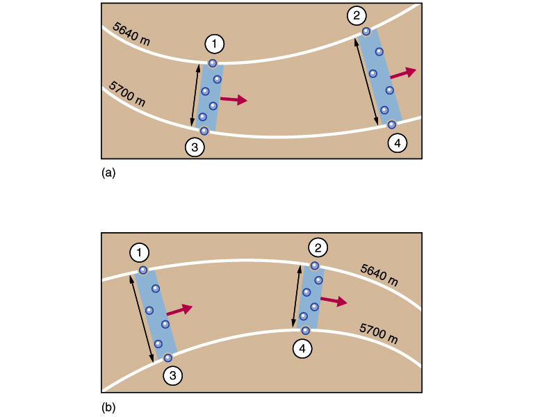
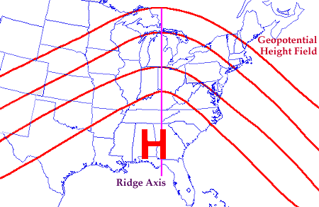
Do the troughs and ridges on the weather map line up perfectly straight? Not usually. To show the center of the trough, we draw a trough axis. At its lowest point, it cuts across each curve.
When the trough axis tilts to the left or right, or curves with respect to the nearest longitude and latitude line, what does that mean?
Does that mean angular momentum is being transported northward or southward? Momentum around a spinning body stays constant according to a well-known conservation law.
I would like to clarify this further.
Angular Momentum: large scale physics.
First, let's define a few terms:
- Law of Conservation - is when the total amount of energy in a system doesn't change, even if its form changes. These conservation laws also apply to energy, linear momentum, angular momentum, mass, and electric charge.
- Momentum - A body's momentum is its tendency to keep moving. Then by conservation momentum stays constant, losing only to secondary forces
- angular momentum - refers to the tendency for something to keep spinning, such as a wheel. The mass and speed of an object can be used to calculate either of these quantities.
- Conservation of Angular Momentum - Rotating objects, such as tornadoes, are subject to the law of conservation of angular momentum.
More on these in a bit. Remember some of your grade-school science projects? For example, consider the following thought exercise. During a steady spin, a figure skater pulls her leg inward before speeding up.
Why? Due to conservation momentum, the speed multiplied by mass multiplied by distance from the center, the axis of rotation, stays pretty constant.
Tightening up reduces her space occupied and her mass stays the same. Keeping the angular momentum constant means increasing her spin rate.
Conservation energy law applied to the air.
Caution: Heavy theory ahead!
Energy can't be created or destroyed, it can only be transformed from one form to another according to the conservation of energy law. Energy is energy, whether it's kinetic energy, potential energy, thermal energy, etc.
Here, the conservation of energy law applies to kinetic energy and potential energy associated with air motion. As a parcel of air rises in the atmosphere, it gains potential energy as it moves to a higher altitude, while losing kinetic energy as gravity slows down its upward motion. As a parcel of air sinks, it loses potential energy as it moves to a lower altitude, but gains kinetic energy as it speeds up downward.
The conservation of energy law also applies to processes like heating and cooling that transfer energy into and out of the air. For example, if air is heated by the sun or a warm surface, it gains thermal energy, which can be converted into kinetic energy or potential energy as it moves. As well, when air is cooled by a cold surface or evaporation, it loses thermal energy, which can also be converted into other forms. Overall, the conservation of energy law can be used to understand and predict the behavior of air and other physical systems because it applies to all forms of energy.
Another thing conserved in the atmosphere is momentum. In the absence of external forces, the conservation of momentum is another fundamental principle of physics. Air molecules and air masses in the atmosphere follow this principle.
Air molecules collide constantly with each other and with other objects in their environment, transferring momentum between them. By distributing the momentum of the air throughout the atmosphere, these collisions keep the total momentum of the system constant.
On a larger scale, momentum conservation applies to air masses, like those associated with weather systems. When a high-pressure system moves into an area, it brings a huge mass of air with it. The high-pressure system can transfer momentum to other air masses, causing them to move in a certain direction.
Also, when a low-pressure system forms, it creates a region of lower atmospheric pressure that draws in air from surrounding areas, creating a flow of air that can be influenced by conservation of momentum. When air moves into a low-pressure area, it gains momentum, which can be transferred to other air masses or objects.
A fundamental principle that helps explain the motion of air in the atmosphere, from molecular motion to large-scale weather systems, is momentum conservation. We can better predict and understand the behavior of the atmosphere by understanding and applying this principle.
Finally, let's look at angular momentum in the air. The conservation of angular momentum applies to rotating objects, including those in the atmosphere. In the atmosphere, this principle applies to cyclones, anticyclones, and other air masses.
An object's angular momentum is its moment of inertia plus its angular velocity. Moment of inertia in the atmosphere is determined by mass distribution, and angular velocity is how fast the air mass is rotating. Unless an external torque acts on an isolated system, the total angular momentum stays constant.
Rotating air masses, like hurricanes or other types of cyclones, are explained by the conservation of angular momentum in the atmosphere. An air mass gains angular momentum as it rotates. As the air mass rotates, this momentum is conserved, and it can be transferred to other air masses or objects.
The conservation of angular momentum also explains why air masses rotate in different directions in different hemispheres. Air masses rotate counterclockwise in the Northern Hemisphere, while they rotate clockwise in the Southern Hemisphere. As a result of the Coriolis effect (an illusion caused by a rotating frame of reference), objects in the atmosphere seem to deflect from a straight path because of the rotation of the Earth.
How does keeping the global balance of angular momentum in the Earth's atmosphere contribute to climate stability.
In the Northern Hemisphere, moving air masses are deflected to the right by the Coriolis force (and to the left in the Southern Hemisphere.) Large-scale circulation patterns in the atmosphere are created by this force, such as the Hadley cell circulation in the tropics.
Warm air rises near the equator, flows towards the poles at high altitudes, then sinks again in the subtropics. Not only does this flow of air carry heat, but it also the "spin" in the air mass away from the equator.
Thus, near the equator, excess eastward momentum builds up in the atmosphere, while the mid-latitudes and polar regions have more westward momentum. In part, this imbalance is offset by large-scale atmospheric waves that propagate from the tropics to the poles taking the momentum with them.
Again, the conservation momentum that accumulates in the equatorial regions migrates towards the poles in order to maintain balance.
Science fair project idea:
Let's say you're holding a fire hose and pointing it east. With the nozzle tilted northeast, the momentum travels upwards, as if towards the North Pole on our weather map. If you point it downwards, it'll dig a hole in the ground.
Asymmetry
In the northern hemisphere, momentum must travel towards the North Pole. That means the trough or ridge, the hose, will tilt more to the left than to the right. Southwest upper winds will be stronger than those from any other direction when this happens, so momentum will shoot north. A demonstration of these concepts would make a good science project idea.
The axis of this ridge is straight up and down. Plus, it's straight. In this case, there's no momentum transfer north or south.
There are other momentum transfer mechanisms. If a curved line fits the trough or ridge better, then it acts like a lens, focusing or defocusing the winds. This is called a confluence or a difluence.
Send the high winds toward the pole and return slower winds equatorward to keep the conservation momentum.
Generally, tighter contour lines, which are more focused, correspond to higher wind speeds and vice versa for more spread out curves. So, looking at increasing or decreasing wind speed observed data on both sides of the ridge or trough can give you the same insight.
Southward anti-conservation momentum transport, which defies conservation, sometimes happens with sudden weather changes. An unusually stormy cold front front can be caused by a digging trough (an upper-level trough that is getting stronger and moving toward the equator, thanks to an upper-atmosphere region with strong winds called a jet streak upstream) and lead to continued cold afterwards.
Also, if you think about it, it makes sense that a low-pressure area would form near the end of the trough. Stronger winds blow away from here, leaving a partial vacuum.
#10
Bonus conservation momentum conundrum
It can also mean poleward momentum transport near one part of the trough and tropic-bound anti-conservation-of-momentum transport elsewhere at the same time. The result can be a local build-up or deficiency in westward momentum, resulting in the creation or destruction of jet streams or fronts.
What's more? A deficiency can cause streams to decouple and new centers of high and/or low pressure can form between them. This rock in the stream gets called a block, such as an Omega Block, where the flow around takes on the shape of the Greek letter Omega, like a country road on your mountain vacation looping around a large obstacle such as a lake.
As a result, things can take a while to get moving again, and regions can end up trapped trapped in long periods of steady, even unusual weather. Then we hear things like…
Rainiest spring ever
I sure hope this cold snap lets up
But you never hear anyone complaining about atmospheric momentum. Do you? Go back from Conservation Momentum to the
Chasing Storms web page.
Search this site for more information now.
What is the relationship between the conservation of angular momentum and meteorology?
In a moving atmosphere, what is the connection between the law of conservation momentum and changes in speed?
Do you have concerns about air pollution in your area??
Perhaps modelling air pollution will provide the answers to your question.
That is what I do on a full-time basis. Find out if it is necessary for your project.
Have your Say...
on the StuffintheAir facebook page
Other topics listed in these guides:
The Stuff-in-the-Air Site Map
And,
Thank you to my research and writing assistants, ChatGPT and WordTune, as well as Wombo and others for the images.
OpenAI's large-scale language generation model (and others provided by Google and Meta), helped generate this text. As soon as draft language is generated, the author reviews, edits, and revises it to their own liking and is responsible for the content.


New! Comments
Do you like what you see here? Please let us know in the box below.