- Air Homepage
- Alberta Air Quality
- Air Quality Dispersion Modelling
- Numerical Weather Prediction NWP Models
How Numerical Weather Prediction NWP models help you assess air quality.
Numerical weather prediction NWP models form the foundation of many air quality assessments. They help us achieve greater accuracy in our forecasts. With these sophisticated tools, you can more easily find out how pollutants disperse over time and space.
The Future of Meteorological Data Modelling with NWP and AERMET - Is your air quality assessment failing because your on-site weather data is only 80% complete or you don't have upper-air soundings? Find out how Numerical Weather Prediction (NWP) models can fill in the gaps in your meteorological records and provide the precise data your regulators need.
Combining NWP output with real-world meteorological data makes using AERMET and CALMET more convenient and accurate. Thus, more and more regulatory bodies and commercial entities use their output to conduct more of their air quality assessments.
 Assessing air quality today
NWP models aren't without challenges, though. When local meteorological data isn't available, experts use substitutes like nearby meteorological stations or interpolation techniques. Gaps in the raw data can introduce uncertainties that require careful handling, but NWP models fill these gaps, leading to better air dispersion modelling even in complex or sparse regions.
In Alberta, Saskatchewan, Manitoba and British Columbia, regulatory frameworks heavily emphasize using Numerical Weather Prediction model output. These models are help us handle a variety of conditions, from routine industrial emissions to more complex environmental concerns.
By using NWP model output in air quality dispersion studies, we'll can see that environmental standards are upheld, and the output can be used to help us find a deeper understanding of our atmosphere. The following are some reasons someone like you might be interested in reading this:
- NWP models revolutionize the process of environmental decision-making.
- Learn how air quality predictions could affect how we treat the environment.
- For industries that have to deal with strict environmental regulations, compliance is essential and modelling might be a part of the requirements.
- Learn how we handle missing meteorological data using this software.
- Learn how these quality and numerical weather prediction NWP models help us tackle pollution in complex terrains.
- Find out how these improved weather forecasts shape our future.
This webpage explains how the western provinces of Canada instruct modellers on how to handle meteorological data. This includes data generated using NWP.
Using AERSCREEN or on-site data to assess Alberta's air quality
Air quality assessment model AERSCREEN generates worst-case meteorological data for your site, so you don't need external meteorological technicians. For more refined assessments, ground-based or modelled meteorological data is better.
 It's not quite this strict in Alberta
There are certain criteria for valid on-site meteorology: at least one year of hourly data, statistically related to longer-term weather, and at least 90% data availability. Missing data can be interpolated, corrected with established profiles, or supplemented with off-site data.
Other applications require five years of modelling using meteorological data from the Alberta Environment and Parks (AEPA) dataset, plus ground-based meteorology when available. On-site data should be handled the same way as missing data. AEPA data alone should be used if ground-based data isn't available or incomplete. Other meteorological datasets aren't acceptable.
The Critical Role of Meteorological Data in Predicting Saskatchewan's Air Quality
Modelling air dispersion requires meteorological data. For this, AERSCREEN and AERMOD are two models with distinct meteorological input requirements. AERMOD requires hourly meteorological data processed through AERMET, while AERSCREEN generates screening data based on surface characteristics.
 Unusual place for a meteorological station
The Ministry of Environment has developed Regional Meteorological Data Sets for AERMOD, covering five years. AERMET and the Weather Research and Forecasting (WRF) model were used to prepare these sets. Modifications or alternate data sources may be needed if the facility has unique surface characteristics.
The dispersion of emissions can be stunted by calm wind conditions. For alternate meteorological stations, AERMOD skips hours with calm winds. There are a lot of ways to fill in gaps when there's missing data.
The different formats of meteorological data files are discussed, along with how to choose representative meteorological stations. Data accuracy depends on QA/QC procedures and adjustments for anemometer height and wind speed.
For accurate air dispersion modeling, selecting appropriate meteorological data and keeping its quality check are crucial.
Numerical weather prediction NWP models provide meteorological data for air dispersion in Manitoba
Choosing meteorological data for air dispersion modelling depends on the complexity of the model.
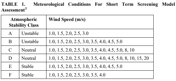
Table 1 below provides default meteorological conditions for screening assessments, which estimate short-term conditions. When in screening mode, these conditions vary based on atmospheric stability class and wind speed.
 Screening Data: Pasquill-Gifford Stability and Velocity
Refined assessments require five consecutive years of meteorological data, including wind direction, temperature, and cloud cover observations. The nearest representative weather station should be able to provide this data. You can waive the five-year requirement if you have at least one year of high-quality hourly data. Gaps in the data should be addressed, and their impact on modeling should be discussed.
Meteorological data quality and quantity affect modelling confidence significantly. An accurate assessment needs to discuss the data's suitability for the site and its potential impact on modeling results. In the dispersion modelling report, you should also discuss factors like fumigation, wind shear, terrain effects, and chemical transformations.
Advanced Meteorological Data for Air Dispersion Modelling in British Columbia
Dispersion models rely on meteorological data, either predetermined conditions (in Screening Models) or hourly sequential data (Refined Models). There are a few options for meteorological input:
- site-specific data,
- data from nearby locations reflecting site conditions, or
- output from Numerical Weather Prediction NWP models.
There are a lot of factors to consider when assessing alternate data sources, like geophysical similarity, climate, instrumentation, and data processing capability. An early consultation with the Ministry is recommended for Level 3 assessments, which are meant for special circumstances.
 Vancouver air quality forecast looks good
Different agencies provide meteorological data in BC, each with their own quirks. Among them are Meteorological Service of Canada (MSC), Ministry of Environment and Climate Change Strategy, which protects natural resources, and various fire weather networks. Siting, instrument type, maintenance, and data quality assurance are all things to consider when using diverse data. In BC, upper-air data are sparse and have to be carefully assessed for applicability prior to incorporating into the data set.
It's best to have up to five years of data for Level 2 or Level 3 Assessments, which are more detailed. Data completeness of 90% is recommended for use in AERMET and CALMET and it's a good idea to collect more data if this limit hasn't been met.
Air quality dispersion models rely on meteorological data as input, which can come from either predetermined conditions or actual observations. In the latter case, it's crucial to have quality-assured data to reduce uncertainty in model predictions.
For meteorological data, the BC guideline recommends site-specific collection programs, measurements from a similar location, or output from numerical weather prediction NWP models. To ensure data representativeness, a site-specific set of data is best. Different factors need to be considered, like geophysical similarity, climate regimes, instrumentation, and data quality, when considering alternate sources.
It may be necessary to establish a new site-specific meteorological collection program for major projects in complex areas with no data sources.
There are several agencies in BC that provide meteorological data. Data like wind speed, direction, temperature, and cloud cover are included. If using these services, it's important to make sure the data is appropriate and compatible with the model.
Short gaps can be filled with interpolation techniques, while longer gaps can be filled with data from nearby sites or numerical weather prediction NWP models. It's important to acknowledge, however, that these approaches introduce uncertainty into the data.
AERMET and CALPUFF need specific data for dispersion modelling, including surface observations and upper-air observations. For long-term modeling assessments, data completeness and quality assurance are essential.
Air quality dispersion modelling relies on selecting appropriate meteorological data sources and making sure to use the best available data quality.
Using AERMOD/AERMET: Various meteorological data inputs are needed for AERMET, a tool for modelling air quality. In the absence of representative airport data, a site-specific meteorological program can be used, but cloud cover information is needed. AERMET can estimate cloud cover if necessary data isn't available.
British Columbia has complex terrain throughout the province, so getting the right upper air data can be tough. It's possible to use nearby soundings or NWP model output. AERMET also handles very low wind speeds, known as "calm" periods. Data format and requirements for integrating site-specific or airport data within AERMET are detailed, including wind speed, direction, temperature, and other parameters. SMERGE is a part of AERMET that helps prepare data files for AERMET. To model air quality accurately, AERMOD needs precise meteorological data formatted by AERMET and it must be based on good input information.
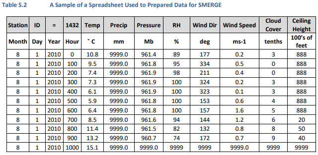
 An example of a table used to prepare meteorological data
In Table 5.2, you'll find a structured format for organizing meteorological data, like temperature, precipitation, pressure, wind direction, etc. Parameters are assigned to columns, and missing values are replaced with placeholders. As shown in Table 5.3, the data can be saved in a comma-delimited (.csv) file. Be sure to include specific header lines and follow the format exactly.
Using CALPUFF/CALMET: Multiple surface data files can be merged into a single file called SURF.DAT, which CALMET can use for modelling. In the case of missing data, CALMET can automatically substitute missing parameters from other surface stations. Upper air data is also needed, and intrinsic tools like READ62 preprocess some formats of upper air data so CALMET can read it.
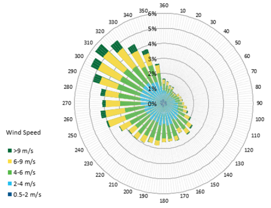
 Graph the weather data
A separate file called PRECIP.DAT is needed for wet deposition calculations if applicable. This file can be prepared with preprocessors like PXEXTRACT and PMERGE, although Canadian agencies supply data in a different format. There are limitations to NWP model output, but it can supplement observational data or replace it.
NWP models can provide meteorological data for areas that lack complete observations, but quality and applicability must be considered carefully. We have about different ways to generate meteorological data for dispersion modelling, which helps us understand how pollutants spread. Here's how it works:
- Numerical Weather Prediction NWP Models: These are computer models that predict weather patterns. They're useful but take a lot of power. Local areas and fine-scale terrain features aren't always accurate.
- A hybrid approach combines NWP output with CALMET to improve accuracy, especially in complex terrain areas.
- This model can generate meteorological data using NWP data alone, observational data alone, or a combination of both. There are a lot of factors to consider, like terrain complexity and data availability.
- Factors like model expertise, terrain complexity, and data availability affect the choice and effectiveness of these methods.
- In CALMET, there are several user-defined parameters and options that require expert judgment. Inclusion/exclusion of certain data points and weighting of observational data are affected by these parameters.
- There are recommendations for when to use each method and how to handle common problems. MMIF is a program that can help you process NWP output for dispersion modelling.
Here's some detailed guidance on how to generate meteorological data for dispersion modelling, taking terrain complexity, data availability, and model expertise into account.
How to set up and run CALMET, which is used to model atmospheric dispersion. Here are some points, but for completeness check the instructions in the BC Air Quality Dispersion Guideline, Section 6. Especially the tables.
Setting it up:
- Select options like vertical velocity, slope flows, and extrapolation of surface wind observations.
- Don't include terrain-forced vertical velocity in the initial guess.
- We explain how to adjust vertical velocity, compute slope flows, and extrapolate wind observations.
Usage of data:
- Use numerical weather prediction NWP models for output or coarse CALMET fields to use as initial guesses.
- For CALMET, define parameters related to surface meteorological data and upper air soundings.
- Establish biases and minimum distances between upper air stations and surface stations.
Interpolating wind fields:
- Specify the radius of influence and weighting of observations for wind field interpolation.
- We explain how to use varying radius of influence and barriers to interpolation.
Modules for diagnostics:
- There are options for surface temperature, lapse rate, and initial guess wind components.
- The parameters for using surface and upper air wind components are detailed.
There are a few more modules. If you're using Lake Breeze, set the parameters. Here's how to do quality assurance and quality control (QA/QC). Evaluation of the model:
- There are recommendations for plotting and analyzing wind vector fields, surface wind speeds, and wind roses.
- There are also suggestions for modelling approaches like CALPUFF for light wind conditions and stagnation.
This passage serves as a comprehensive guide for setting up and running CALMET for atmospheric dispersion modelling, including data preparation, model configuration, and results evaluation.
Air Quality Expertise with Calvin Consulting
Are you concerned about air quality permits or environmental impact assessments? It's okay. Air dispersion modelling can be complicated and time-consuming. Don't let that hold you back!
You can trust Calvin Consulting Group Ltd. for all your air quality dispersion modelling needs. We've got over 30 years of experience and Canada's best dispersion modellers.
Calvin Consulting is the perfect fit for you because:
- Our team has trained staff at government agencies and completed countless projects. We'll make sure your project meets all regulatory requirements, every step of the way.
- Get meteorological data without the hassle. From site-specific data collection to quality assurance, we've got you covered.
- We know your time is valuable. We make sure your project gets done fast and efficiently.
- Getting generic solutions won't cut it. Get a custom assessment that fits your needs. No matter what it is, you can rely on us for clear, concise reports that help you move forward.
Ready for some peace of mind? Get in touch with Barry at Calvin Consulting today.

We'll handle the air quality details so you can focus on your business.
Clean air is our Passion...Regulatory Compliance is our Business.
The Numerical Weather Prediction NWP model is refining air quality and how we conduct dispersion modelling.
Models like these simulate weather conditions, so they're great for environmental assessments, especially in areas where empirical data is sparse. When combined with observational meteorological data, they take us towards greater accuracy in our regulatory air dispersion studies.
Data interpolation or similar data substitutes are needed when we have gaps in on-site meteorological data. NWP models help us deal with problems posed by complex terrain and stagnant air. Making reliable, science-backed environmental decisions can start with understanding NWP models.
Do you have concerns about air pollution in your area??
Perhaps modelling air pollution will provide the answers to your question.
That is what I do on a full-time basis. Find out if it is necessary for your project.
Have your Say...
on the StuffintheAir facebook page
Other topics listed in these guides:
The Stuff-in-the-Air Site Map
And,
Thank you to my research and writing assistants, ChatGPT and WordTune, as well as Wombo and others for the images.
OpenAI's large-scale language generation model (and others provided by Google and Meta), helped generate this text. As soon as draft language is generated, the author reviews, edits, and revises it to their own liking and is responsible for the content.

New! Comments
Do you like what you see here? Please let us know in the box below.