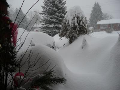
Stayner Winter Wonderland
by Jo-Anne Crane
(Stayner Ontario)

Winter wonderland in Stayner Ontario
This is what 3 days of snowing looks like in Stayner!
Barry's Response - Stayner and surrounding areas near Georgian Bay are experiencing a lot of lake-effect snow...typical of this time of year when the water is still open and much warmer than the air that flows directly over it.
Stayner, or Nottawasaga Station, lies at the southern end of Georgian Bay, about an hour south of Toronto. This community and the rest of Clearview Township receives a good deal of this type of snow. "Cottage Country", the Georgian Triangle, and generally Central Ontario also get winter weather like this.
This open water not only releases vapour into the air, but also injects heat. CAPE (convective available potential energy) is abnormally high in this mixture. It's partly from direct heat transfer and partly from moisture latent heat.
As a result, the air can become much more unstable than it otherwise would, especially when it interacts with wind shear and terrain. A parcel of air gets wrung out of moisture by instability and convection. Is there moisture around? Plenty.
search this site for more information now.
Snowstorms caused by lake-effect are common during the winter months along the shores of the Great Lakes.
Snowstorms usually happen 1–2 days after a synoptic-scale low pressure system passes and northwesterly flow is established.
When cold air passes over a relatively warm body of water, a lake effect snowstorm happens. Air picks up moisture and heat from the lake, so it rises. When the moisture cools and condenses in the atmosphere, it turns into snow.
It's no secret that the Great Lakes, which hold over 20% of the world's freshwater, are especially prone to lake effect storms. The main difference between lake-effect snow and regular snow is how it's fuelled. Winter storms are low-pressure storms, whereas lake effect storms are high-pressure storms.
Winter storms can occur anywhere without lakes nearby, but lake-effect snow only occurs around the Great Lakes.
As dry, freezing air moves along warmer lake water, it picks up moisture and heat. As a result, some of the lake water evaporates into the air, making it warmer and wetter. All the moisture gets dumped on the ground as the air cools and moves away from the lake. When it's cold enough, it dumps a lot of snow.
Here's an Example: Buffalo's single biggest lake-effect snowstorm happened in December 2001, when 81.5" accumulated at the official city weather service site at the airport. Also, a state record for a single snowstorm dropped 85.0" (215 cm, over 7 feet) in the Lake Michigan snow belt around Petoskey, Michigan.
Comments for Stayner Winter Wonderland
|
||
|
||
Do you have concerns about air pollution in your area??
Perhaps modelling air pollution will provide the answers to your question.
That is what I do on a full-time basis. Find out if it is necessary for your project.
Have your Say...
on the StuffintheAir facebook page
Other topics listed in these guides:
The Stuff-in-the-Air Site Map
And,
Thank you to my research and writing assistants, ChatGPT and WordTune, as well as Wombo and others for the images.
OpenAI's large-scale language generation model (and others provided by Google and Meta), helped generate this text. As soon as draft language is generated, the author reviews, edits, and revises it to their own liking and is responsible for the content.


